|
|
 |
 |
 |
 |
 |
 |
 |
 |
 |
|
 |
 |
 |
 |
 |
 |
 |
 |
 |
 |
 |
 |
 |
 |
 |
 |
 |
 |
IMIA REPORT  
Industry News, Profiles and Future Events
April 2015
|
IMIA is an international organization where mapmakers, publishers, geospatial technology companies, location-based services, content producers, and distributors come together to both connect and to conduct business in the spatial information and map related industry. It is a global organization and welcomes members from every corner of the globe. The Association is made up of three regions: IMIA EAME (Europe, Africa and Middle East), IMIA Americas (North America, South America, Canada, and Mexico) and IMIA Asia Pacific (Australia, New Zealand and Asia Pacific).
The IMIA Report reports the current issues of the worldwide mapping industry giving members information on new products, member news, plus items of interest to those in the industry. We encourage all our members to send to IMIA Headquarters their new product information and press releases for distribution. Advertising is available.
|
|
National Geographic Traveler Magazine has Announced
its Annual Tours of a Lifetime Selection
|

NORTH AMERICA
|

PACIFIC ISLANDS & OCEANIA
|
|
National Geographic Traveler magazine has announced its annual Tours of a Lifetime selection, now in its 10th year. The 2015 list features 50 of the world’s best guided trips chosen by the editors of National Geographic Traveler.
In addition, the editors picked five of their favorite expeditions of a lifetime offered by National Geographic. The list and details about the trips can be viewed in National Geographic Traveler magazine’s May 2015 issue and online at http://travel.nationalgeographic.com/travel/tours/.
“This year marks 10 years of our editors selecting the world’s best guided tours,” said Norie Quintos, acting editor in chief of National Geographic Traveler magazine. “In that time, the types of immersive and experiential trips have only multiplied; tours are going farther and deeper than ever before.”
From stalking lion tracks in the Serengeti to kayaking secret coves in Croatia to following the wine trail in the Republic of Georgia, the 50 best guided tours selected this year offer authentic travel experiences that are sure to leave participants engaged and ensconced in culture. The additional five unique tours from the National Geographic Travel family include inspiring expert-led adventures from Australia to Ireland to the Pacific Islands.
Sailing a dhow around a Mozambique archipelago, riding a dogsled in Greenland, sampling wine fermented in clay vessels in the Republic of Georgia-these are far from everyday experiences. With a few clicks of your cursor, however, they’re yours to enjoy. In the ten years we’ve curated our annual roundup of the best guided trips, sustainable tours that reflect the National Geographic Society’s mission to inspire, illuminate, and teach have proliferated. Not long ago, for example, travelers interested in small-group tours to India settled for a handful of well-trod itineraries; today, choices run from seeing antiquities in Gujarat to trekking with Himalayan yak herders. Driving much of this growth: increasingly sophisticated travelers keen on customized trips and just enough adventure. Eager to join them? Start here.
|
|
Compelling Story Maps for Earth Day 2015
|
|

In honor of Earth Day, Esri has compiled a collection of story maps you might be interested in sharing today. On this 45th anniversary, we invite you to take a few minutes to explore these compelling interactive maps created using Esri’s story maps technology that detail how our planet is changing. Feel free to share or embed these maps as part of your Earth Day coverage and please let us know if you want more information about any of them.
The Ten Most-Visited US Urban Parks
From Central Park to Coney Island, explore the ten most popular urban parks in the US.
The Age of Humans
Explore an atlas of human influences, as well as the cities that are helping to reshape the way our species interacts with the planet.
A Tapestry of World Ecosystems
Tour some of the most ecologically diverse locations on the planet, from mountains in California to forests in Puerto Rico.
Glaciers on the Move
Explore the dramatic change in ice cover and glacial retreat through a series of before and after images.
Reshaping the Earth
Compare decades of Landsat imagery showing how humans have radically transformed 12 locations on the planet since 1990.
Our Global Footprint
Examine each country’s ecological footprint and biocapcity, to see which countries are consuming significantly more resources than they’re preserving.
Blog: Five Compelling Story Maps for Earth Day 2015
|
Atlas Obscura
06 Apr 2015
|
|
|
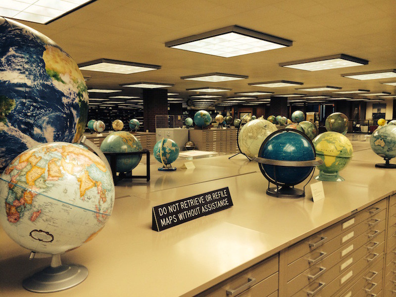
The American Geographical Society Library at the
University of Wisconsin, Milwaukee.
(Photo: Luke Spencer)
|
Within the campus of University of Wisconsin-Milwaukee is a geographer’s treasure trove: over a million artifacts from the American Geographical Society, one of the most incredible collections of maps, atlases and globes to be found in America. But, ironically, the library is practically unexplored territory. When I asked for directions on campus many students themselves didn’t know it was there.
It’s an inconspicuous home for a storied collection: this is the final resting place of the library of the illustrious American Geographical Society. Once a powerhouse of exploratory resources, the organization had fallen on hard times in the late 1970s. The private donations and corporate funding on which they had been reliant, had reduced to a trickle, and the Society was forced to sell its imposing neo-classical headquarters in Manhattan’s Washington Heights. Eventually downsizing to a small rental office in Brooklyn, the Society was adamant that its unparalleled collection should be kept intact. Resisting the temptation to sell off its valuable archive, including the remarkable signed AGS Fliers and Explorers Globe, they undertook a nationwide search for a suitable home. As current AGS President, Professor Jerry Dobson explains, “The truth is that our revenues didn’t allow us to take care of the collection in a proper manner, so we held a national competition for a suitable repository.”
Faculty members of the geography department at UWM heard what was happening and applied. The University itself was barely 20 years old, but had a brand new library building large enough to house the entire collection. The New York States Attorney office wasn’t happy that the rich cultural heritage and treasures of the Society would be leaving the State of New York, but with no other viable option to take the collection as a whole, the decision was taken to send the collection to Wisconsin in 1978.
To read more … http://www.atlasobscura.com/articles/the-most-amazing-map-library-that-you-ve-never-heard-of?utm_source=Atlas+Obscura&utm_campaign=d2f00f819e-Newsletter_04_10_154_9_2015&utm_medium=email&utm_term=0_62ba9246c0-d2f00f819e-59895881&ct=t%28Newsletter_04_10_154_9_2015%29&mc_cid=d2f00f819e&mc_eid=a8fffad6cc
|
Twelve Inventions That Could Save the World
|
MAKERS DOZEN
SHARE
WRITTEN BY
Mike Murphy@mcwm
8 hours ago
The European Patent Office (EPO) has announced its finalists for the 2015 European Inventor Awards, honoring brilliant inventions from a range of scientific fields. The EPO will have its work cut out choosing winners-everyone on the list is working on or has created something groundbreaking.
A dozen finalists are grouped into four categories, including one for non-European inventors; three additional finalists are eligible for a lifetime achievement recognition. One winner will be selected from each category, and then the public can vote on the overall winner, with the awards taking place on June 11. Here’s the shortlist, broken out by category.
Industry
Franz Amtmann (Austria), Philippe Maugars (France)
This team of inventors came up with the technology behind Near Field Communication (NFC). This form of radio technology is what powers mobile payments like Apple Pay and Google Wallet. The technology is likely to find its way into more applications soon: the Washington D.C. subway is piloting an NFC payments system, and London is looking into it, too, as is the other subway.
Gunnar Asplund (Sweden)
Renewable energy plants are often far from centers of population-we don’t tend to have dams or solar fields near cities-which makes getting the power from the plants to the people difficult (the farther the power has to travel, the more energy is lost to resistance). Asplund has found a way to bury cables that can transport energy over thousands of kilometers without losing a volt.
Jean-Christophe Giron (France)
Giron has invented an “intelligent” window. An electrified glazing on his windows can convert the sun’s rays into warmth to heat homes in winter. The glazing also darkens in the summer (think transition lenses) to limit the amount of sunlight that gets in. Giron’s invention can reduce a building’s energy costs by up to 20%, according to the EPO. Giron is vice president of technology at SAGE Electrochromics, a division of Paris-based building materials company Saint-Gobain.
Small and Medium-Sized Enterprises
John Elvesjo and Marten Skogo (Sweden)
This Swedish team invented the eye-tracking system called Tobii that lets users control computers with just their eyes. An infrared sensor tracks the direction of the user’s eyeballs, essentially turning your eyes into a computer mouse. This technology could help people with mobility issues to interact with computers like never before, the EPO said.
Michel Lescanne (France)
Lescanne has developed a peanut paste called Plumpy’nut to help fight famine. Nearly 20 million children under the age of five suffer from acute malnutrition, according to the World Health Organization. Usually they would need to be taken to hospital to be treated, but with Lescanne’s paste, they can be treated at home.
Laura Johanna Van’t Veer (Netherlands)
Van’t Veer developed a gene test that shows women with early stage breast cancer whether they are likely to need chemotherapy. According to the EPO, her invention means that 20% to 30% fewer patients would be steered into chemotherapy as part of their treatment. After patenting the gene test in 2001, Van’t Veer and a partner started a diagnostics firm called Agendia, which markets the test under the name MammaPrint.
Research
Luke Alphey (United Kingdom)
Alphey has invented a way to combat Dengue fever by genetically controlling mosquitos to breed out the ones that carry the disease. The impact is potentially huge: According to WHO, roughly half of the world’s population is at risk of contracting the potentially fatal disease.
Hendrik Marius Jonkers (Netherlands)
Jonkers has invented a “bioconcrete” containing bacteria that naturally produce calcium carbonate (limestone). The bacteria can lie dormant for up to 200 years. When the concrete cracks, it activates the bacteria, which seal up the cracks. Though its production is currently twice as costly as that of regular concrete, Jonkers’ invention could potentially extend the life of buildings and roads worldwide by decades.
Ludwik Leibler (France)
Leibler has invented vitrimers, a new type of recyclable, self-healing plastic. Vitrimers are as sturdy as glass, and when heated, can repair damages to their surfaces. So the next time you drop your smart phone, a little heat could heal the cracks and save you a few hundred dollars. Leibler is also developing a way to use his material to heal wounds, the EPO said.
Non-European Countries
Ian Frazer, Jian Zhou (Australia, China)
This is the team that developed the Gardasil and Cervarix vaccines against the Human papillomavirus (HPV), which is linked to 99% of cervical cancer cases. Vaccinations already have had a significant effecton the prevalence of HPV in young women. Zhou died in 1999-Gardasil, marketed by Merck, was not cleared for use in Europe and the US until 2006. Cervarix, made by GlaxoSmithKline, won approval in Europe the following year.
Elizabeth Holmes (US)
Holmes developed a way to test for a plethora of health issues using a single drop of blood obtained with a finger prick. Holmes’ method is “virtually painless” and takes only hours to get results, the EPO said. The Stanford University dropout is now, according to Forbes, the world’s “youngest self-made woman billionaire.”
Sumio Iijima, Akira Koshio, Masako Yudasaka (Japan)
Carbon nanotubes are a futuristic material that seem right out of a movie. They’re harder than diamonds and conduct electricity better than copper. They may even one day replace silicon as the material that our computer chips are made from. And their discovery, the EPO says, was one of the biggest findings in decades for the field of material sciences.
Lifetime Achievement
The EPO also will be awarding a lifetime achievement honor to one of the following: Ivars Kalvins of Latvia, for his work on preventing and curing diseases; Kornelis Schouhamer Immink of the Netherlands, for creating the technology to store large quantities of data on optical disks like the CD and Blu-Ray; and Andreas Manz of Switzerland, for inventing the “laboratory on a microchip.”
http://qz.com/388324/twelve-inventions-that-could-change-the-world/
|
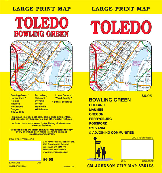
| Large Print Maps at GM Johnson |
|
Friends and Business Associates, this is our latest news from our website. We were sent this picture from one of our map users. I was impressed because from the photo you could still see the names on the map. Hence it led me to ask Troy (our in office web designer) to add it to our blog.
|
|
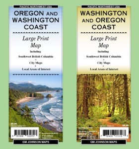
| GM Johnson Maps is starting to create more large print maps. |
At GM Johnson Maps we are starting to create more large print maps. You can see our Washington / Oregon Coast Large Print Map in action (In use by some early 20 year old road trippers in Oregon).
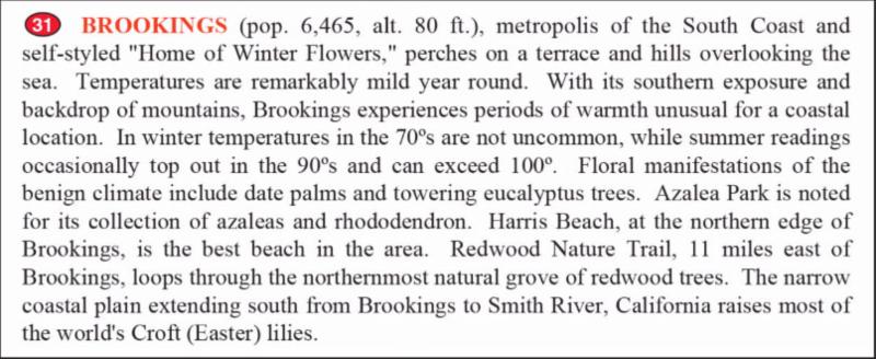
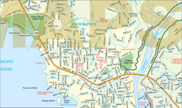
Our Washington and Oregon Coast Map is one of our best sellers, selling more than 170,000 copies since 2009. It features nice write ups on cities and spots all down the coast. In addition we have insets of cities down the coast. See example Brookings, Oregon.
The descriptive text of different areas turns the Washington / Oregon Coast large print map into a guide map of the area. Other examples of this are our Indian County / Four corners map and Portland, Oregon regional map. Check out our new Toledo / Bowling Green, Ohio large print map.
GM Johnson & Associates Ltd.
Maps Publishers
2323 Boundary Road, Suite 207
Vancouver, BC V5M 4V8 Canada
Phone: 604 299 7074
Fax: 604 299 7095
|
| Google’s U.S. Wireless Service on Brink of Launch? |
By Damon Poeter
April 21, 2015 10:13pm EST
Google could lift the curtain as early as Wednesday on a new wireless service, according to The Wall Street Journal.
Google could lift the curtain as early as Wednesday on a new wireless service in the United States with pay-as-you-go data services, which would see the Internet giant partner with Sprint and T-Mobile to carry cellular traffic.
In the works for several years and rumored to be approaching a launch date since January, Google’s wireless service is now on the brink of becoming a reality, according to The Wall Street Journal.
But as reported earlier, the new service may initially only work on Google’s own Android-based Nexus 6 smartphone, the Journal said, citing unnamed sources. Google did not immediately respond to a request for comment.
Sundar Pichai, Google’s senior vice president of Android, Chrome, and Google Apps, confirmed during a keynote at Mobile World Congress in Barcelona in February that Google is planning wireless service offerings in the U.S. and elsewhere. Pichai described the project as a “small scale” concept that wouldn’t bring Google into a large-scale competition with major mobile carriers.
But the Journal argued that Google’s U.S. service could put pressure on U.S. carriers to change the way they charge customers for data. The addition of pay-as-you-go data is a “key development” in the rollout of Google’s U.S. wireless service, which “could further push carriers to do away with lucrative ‘breakage'” data billing structures, according to the newspaper.
|
|
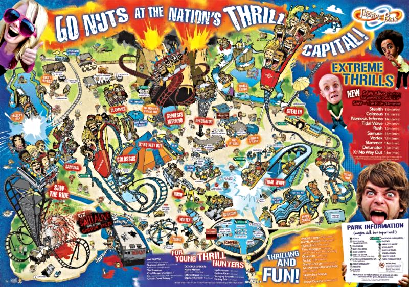
Have you ever considered the importance of theme park maps? Can their appearance subtly change a visitors perception? Do theme park maps contain hidden codes and messages? In this article, CoasterForce member Radaxian takes an in-depth look at Thorpe Park’s maps over the years and how they reflect the park’s transformation.
Written by: Serena Cavalera
CoasterForce
Date Published: 16 March 2013
Theme park maps are a unique entity of cultural text. A standard part of a visitor’s theme park experience is receiving a free, colourful map of the park upon entry. But unlike other maps, the purpose of the theme park map is not predominantly navigational; in fact, depictions of pathways often get lost beneath the maps pragmatic codes of pleasure experience. As theme park visitors have already paid to enter the park; the purpose of the map is not to sell the experience, but to aid the visitor’s immersion within it. The theme park map is a text distinctive in its hyperreal separateness; applying its own particular style and codes that one wouldn’t find anywhere else, it can therefore be recognised as a textual genre in its own right.
The particular focus in this work shall be the 2010 theme park map for Thorpe Park; an English theme park established in 1979 which has recently undergone a marketing transformation due to its 1998 purchase by Merlin Entertainments. To read more …
http://www.coasterforce.com/cf-media/articles/the-importance-of-theme-park-maps
|
|
Loch Ness, Scottish Highlands
Google
Explore the surface and dive underwater in the freshwater lake of Loch Ness. Take in its haunting beauty, made darker still by the peat particles found …
Google Maps Engine to CartoDB: What Does the Transition Look Like?
Cloud Sherpas
By now, we all know about the deprecation of Google Maps Engine. With support officially ending in January 2016, many businesses are already …
Astronomers Found an Unusual Supervoid while Surveying the Skies
Capital Wired
Astronomers recently discovered one of the largest supervoid structures in the Universe. The structure, dubbed the Cold Spot, is a 1.8 billion …
TomTom Multi-Sport Cardio: GPS Watch Review
Live Science
The TomTom Multi-Sport Cardio is a GPS watch that tracks running, indoor swimming and cycling. The watch has a built-in heart rate sensor that …
GPs to cut back on expensive, risky tests in bid to save funds, protect patients
ABC Online
Under the program, GPs and specialists will nominate common tests and scans that are overused or often unneeded and will then be urged to cut …
URISAA GIS-Pro and NWGIS 2015 Conference Details Announced
GISuser.com (press release)
Des Plaines, IL (April 20, 2015) URISA, the Northwest GIS Users’ Group(NWGIS), and the Northern Rockies and Washington URISA Chapters are
Use Word 2010’s new Navigation pane to efficiently browse and organize documents
TechRepublic
For the Navigation Pane to work for you, apply Word’s built-in heading styles. If you don’t like the styles’ attributes, change them. This feature is new to …
East View’s long-standing partnership with various national mapping agencies allows us to bring to market a variety of authoritative map series and geodata options over most of the world. In this week’s edition of the EVG TARGET, we’re highlighting Syria …
ITMB is proud to release the Tonga, Solomon, and Cook Islands Map Pack …
NASA Astronaut Scott Kelly Kicks Off Geography Quiz from ISS
NBCNews.com
Love quizzes? NASA astronaut Scott Kelly is holding one from the International Space Station, which orbits 220 miles above the Earth’s surface. Kelly …
|
|
|
IMIA Blog – “What is a Map?”
|
|
|
By Dave McIlhagga
Founder & CEO
MapSherpa
Remember the good old days when mappers ruled the world, and every map that any mortal saw was sourced, designed, built, edited, and published by pick your favourite map company? The world has changed since then, and the consensus view from many in and out of the industry is that there has been a switchover from paper to digital. At it’s simplest one will often hear “Everyone just uses Google Maps”. Of course the world is far from that simple, and this argument simply doesn’t speak to why people use and need maps in the first place.
What actually happened when Google Earth was launched
What was the first thing you, I and everyone else did when we discovered Google Earth? We went straight to our home – the first time many of us could experience this ultimately unique personal map. The lesson here is simple – maps are highly personal and unique to each user, as they represent many things that have specific meaning to each of us:
- A potential trip I’m planning to take to Venice
- My family’s epic memorable journey through the Alps
- How are my stores performing in different parts of the city
- Is that heavy rainfall going to hit my neighbourhood?
All that technology has done here is enabled you as a consumer to do what you’ve always wanted to do with maps since the beginning of time – make the map mine!
In 1980, Alvin Toffler, the brilliant futurologist, coined the term “Prosumer” – the consumer who could play an active role in producing their own products. Toffler predicted that technology was going to enable consumers to have a different relationship with product vendors and providers – they would become part of the process of creating the end products.
In our industry, OpenStreetMap is the most dramatic example of this concept in action. A consumer driven development of a new source of map content, that is ultimately becoming part of consumer experiences and products.
Arguably GPS in-car navigation devices, MapQuest and later Google Maps, maps on our mobile devices, services like MapMyRun, AllTrails, and Yelp make heavy usage of maps to make every map experience one that makes that map feel like mine.
So does that mean the paper map is now obsolete? Absolutely not. In addition to the traditional mass produced maps which in many areas have strong and growing sales, the same technologies enabling a unique map experience in a digital form, are empowering custom and small order production of printed products.
Ever improving consumer technologies combined with more cost effective, high quality digital printing are driving an interesting phenomenon of unique or small run printed products. A couple of my favourite examples:
- Wallpapered – Custom Wallpaper Maps
- Splash Maps – Custom Maps for the Outdoors on Fabric
- And remember that OpenStreetMap content the world’s consumers are contributing to?
- Well at monochrome.com it’s consumable now on a skirt!
What does this mean for me as a cartographer, GIS analyst, or more fundamentally a “Geographer”?
In this context where everyone can be part of making the map mine, I believe that the role of the geographer, the cartographer and the GIS professional has never been more important than it is today. But our role is changing. Our mindset is shifting from being the gatekeeper who controls the process, to an enabler who works to ensure that the end consumer can get as high quality a product as possible in an environment where the consumer can push a lot of the buttons. That’s a difficult change for many of us – but a transition we will make as part of raising the cartographic bar for everyone in this new era of map making.
What does this mean for our industry?
The past decade in particular has been a time of tremendous change when the words of Charles Darwin have never been more relevant: It is not the strongest of the species that survives, nor the most intelligent that survives. It is the one that is most adaptable to change. I also believe that the companies that have recognized that no single company can do all parts of product delivery themselves have proven to be the adaptable ones. It is the companies that have embraced partnership and co-opetition that have been able to adapt their businesses, and by and large, are growing and thriving in our business.
Never before has the need for this dynamic of partnership been stronger. The future success of each of our businesses must drive us to recognize the unique role we play in an ever more complex industry, and to seek out the relationships that together can deliver the map experience today’s consumer is demanding.
The good new days
A very prescient individual told me a few years ago that he was going through the most important and difficult transformation of his business he’d ever experienced. It was executing a mind shift from success through selling a widget to millions of customers, to success through selling a million widgets to a million customers. Last I heard from him, he was well on his way to achieving his goal.
When it comes to maps, there’s an amazing satisfaction in thinking of my own career and role differently. What’s more satisfying – being part of selling a million copies of a single map? Or being part of giving a million people each their own unique map experience? The good old days had their place, but the good news days show promise of an exciting new chapter for our industry.
|
|
The Power of Maps – a Joint Conference with
the Australian and New Zealand Map Society &
the Mapping Sciences Institute
April 29 – May 01
Canberra, Australia
Esri International User Conference
July 20 – 24
San Diego, CA USA
International Cartographic Association (ICA)
August 23 – 28
Rio de Janeiro, Brazil
Intergeo / IMIA EAME Conference
September 15 – 17
Stuttgart, Germany
IMIA Americas Region Conference ‘International Map Year’
September 27 – 29
Washington, D.C. USA
Frankfurt Book Fair
October 14 – 18
Frankfurt, Germany
IMIA Asia Pacific Region Conference ‘International Map Year’
November 15 – 17
Brisbane, Australia
IMIA Website Host and Developer: NextByte Technologies Ltd., India
|
|
|
|
 |
|
 |
|
 |
 |
 |
 |
 |
 |
 |
 |
 |
|
|
|