Professional Hunter Donnelle Johnson of HuntData Shares Necessities for Pros and Novices on the Hunt
Every year more than 300,000 hunting licenses are sold in Colorado to those in search of big game such as deer, elk, moose, pronghorn and even mountain lions. In a state of outdoor recreationalists, the billion-dollar industry is an economic driver that trails only behind skiing, with consumers spending approximately $21 billion dollars on trips and equipment in 2012 alone.
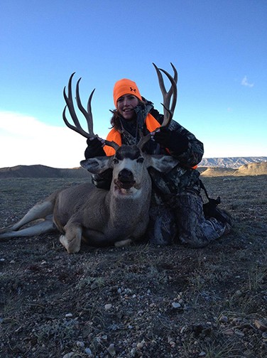
With such high costs, there’s little room for experienced hunters such as Donnelle Johnson to lose focus on the goal. Not uncommon, but still scarce, she joins the ranks of more than 13.7 million hunters nationwide, 11 percent of which are women. Hunting for several years now, Donnelle is co-owner of HuntData, a company borne from the frustration of not knowing where to hunt and the time-consuming process of finding a successful hunting spot. Today, Donnelle leads hunting excursions and on occasion can be coaxed into sharing one of her many stories of how she has taken down a 6×6 bull elk with only a bow. Needless to say, Donnelle has gained the respect of peers who appreciate the skill and patience needed to take down a large bull elk from no further than 30 to 40 yards. Finding big game is also part of her expertise, and she’s always ready to share her experience.
As part owner of a map publishing company and a hunter herself, Donnelle recognizes the importance of maps not only from a directional point of view but from a hunter’s perspective. Understanding where you are in relation to game herds is extremely important, especially when trying to delineate public lands from private property. With boundaries not often marked, trespassing and hunting on private land can rack up thousands of dollars in fines for the novice hunter. As a professional hunter, Donnelle is the first to attest that it can happen to the best of hunters.

“Huntdata’s motto has always been, ‘Where to Hunt’ because so often both professional and amateur hunters can lose valuable time in areas where they’re more likely to see others hunters than animals,” said Donnelle. “With the technology today, there’s no reason to get lost. Paper maps and data are always helpful, but with the combination of apps like Avenza’s PDF Maps app, the chances of finding a herd during any given time of the year as well as understanding public and private property boundaries can make the experience worthwhile.”
Avenza Systems, Inc., a leading developer of cartographic software, created a mobile app called PDF Maps for iOS and Android devices so that map publishers and individual cartographers could upload paper maps at no cost. Now in a digital format, maps could easily be downloaded onto a smartphone. Paired together with mobile devices that use GPS, the PDF Maps app provided the best of all worlds – the ability to read details clearly like a paper map, find your location with GPS and search for direction like a Google map, all without the need of cell service.
As a professional hunter, Donnelle admits to getting ‘lost’ in the hunting experience, but she is very rarely lost in the woods due in part to the readily available and often free tools accessible on smartphones. Donnelle provides hunting classes as part of Mossy Oak and Bass Pro Shop’s ProStaff. A common piece of advice she often shares to those new to the sport, is to download the free PDF Maps app to familiarize themselves to the local hunting grounds. According to Donnelle, there are several expensive GPS devices to take advantage of, but with apps that are free to use and several maps available at no additional cost, anyone with a mobile device like an iPhone or Android can refer to it on hunting excursions. Out-of-town Outdoor enthusiasts can download maps through Avenza’s in-app Map Store 24 hours a day and easily prepare well in advance, quickly and conveniently
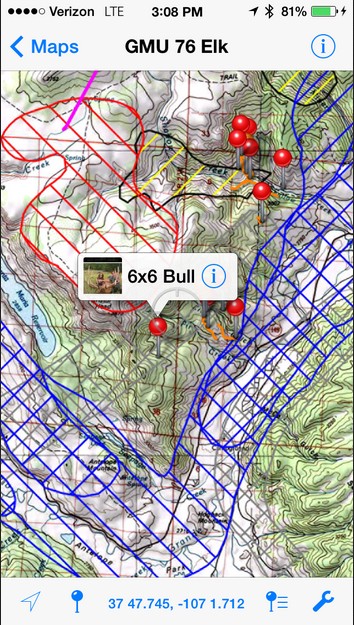
Although HuntData’s digital maps aren’t currently available for purchase in Avenza’s in-app map store, hunting maps for the Colorado, Wyoming and Arizona areas can be purchased from the HuntData site then downloaded to the Avenza PDF Maps app – this includes topo maps, elk concentrations maps and land ownership maps. As any active outdoorsman will corroborate, using a phone provides limited to no cell service on a hunt. Maps on Google Earth are helpful, however they require a data connection in order to stream the maps, which can leave hunters in a predicament if they’re out of cell range. Avenza’s PDF Maps app stores the maps on the device and accesses the GPS capabilities on iOS devices and Androids, making it an indispensable tool when out in the field, and especially when there is no data. Furthermore, the maps usually found on Google or Apple Maps do not have accurate hunting and topographic detail, if any at all, whereas PDF Maps gives access to specialized maps for almost any outdoor/recreational purpose.
More About HuntData and Donnelle Johnson
 Donnelle Johnson is a hunter, fisherwoman, CPA, photographer and a musician. She is co-founder of HuntData with her husband David. She is on the Mossy Oak and Bass Pro Shops Redhead ProStaff. She promotes women and youth in the outdoors through various speaking engagements.
HuntData LLC was founded in 1994 after Dave and Donnelle Johnson moved to Colorado and spent several frustrating years trying to figure out where to hunt. In early 1994 Dave compiled statistics in a spreadsheet for many different units. His goal was to find a new, successful hunting spot. The process was time consuming and led to an outcome he didn’t anticipate – several friends started asking for the spreadsheet. Since then, the Company has introduced many more products, Hunt98, Hunt2000 and finally BigGameCD. The products have moved from purely data-driven databases to products with mapping and consulting capabilities. More information can be found at: www.hundata.com
More about Avenza’s PDF Maps app
Avenza’s PDF Maps app is an all-inclusive solution for the transfer of conventional paper maps to digitized, interactive PDFs readily available for handheld mobile devices on the iOS and Android platform. It allows for consumers and businesses to utilize and purchase maps directly to and from their devices; any geo-referenced map may be uploaded and made available for purchase in a compressed, digital version which is both visually brilliant as well as convenient.
Avenza PDF maps app features the ability to:
- Search for places and points of interest on any map using the Google database
- Export, import and share waypoints and associated attribute data, including photos
- Measure distances and areas and estimate walking times
- Download and carry multiple maps on one device similar to music and books
- Import KML waypoints (including images and custom pins) exported from PDF Maps or other software such as Google Earth or Avenza MAPublisher
For more information visit www.avenza.com or call (416) 487-5116.
# # #
Contributor: Ted Florence, Christine Simmons and Donnelle Johnson
Company: Avenza System Inc.
Platinum Sponsors

Gold Sponsors
![]()
![]()
![]()
Silver Sponsors
Bronze Sponsors
