|
Connecting the Business of Maps Worldwide
|
|
|
|
IMIA REPORT
Industry News, Profiles and Future Events
January 2015
|
|
International Map Industry Association (IMIA)
|
IMIA is an international organization where mapmakers, publishers, geospatial technology companies, location-based services, content producers, and distributors come together to both connect and to conduct business in the spatial information and map related industry. It is a global organization and welcomes members from every corner of the globe. The Association is made up of three regions: IMIA EAME (Europe, Africa and Middle East), IMIA Americas (North America, South America, Canada, and Mexico) and IMIA Asia Pacific (Australia, New Zealand and Asia Pacific).
The IMIA Report reports the current issues of the worldwide mapping industry giving members information on new products, member news, plus items of interest to those in the industry. We encourage all our members to send to IMIA Headquarters their new product information and press releases for distribution. Advertising is available.
|
|
|
If you look at the beautifully illustrated fantasy maps on posters, in books, and across the Internet and wish that you could make such incredible pieces of worldbuilding, then you’re in luck. We have some guidelines for making your maps better, more beautiful, and easier to understand.
1. Understand how your map tells a story.
Jason Thompson, an io9 contributor who has created some truly spectacular D&D maps as well as maps of H.P. Lovecraft’s Dreamlands, points out that the very act of looking at a map can fire up a person’s imagination. He told us, “You look at a map and this area is waiting for you to go to it.” Look …
|
The Fuse Joplin
The year 2014 will remain in the sweet memories of many technology enthusiasts as lots of happenings took place and among the major ones were the takeover deals at Facebook and Microsoft, with each giant company taking over the largest instant messaging app, WhatsApp, and the former king of the mobile industry, Nokia, respectively.
The latter deal has led to a number of revolutionary changes in Microsoft, where this company has taken the path of mobile phone manufacturing, a trend that has led to the re-emergence of the Nokia Here Maps, but now under the new brand, Microsoft. This deal raised some eyebrows in the world of communications and business, but this was something that was meant to come, sooner or later.
Nokia was once a top dog when it comes to the manufacturing of mobile phones. However, things started taking a different turn when the smartphone technology came in, especially with the advent of the Android OS and the iOS operating systems, which were largely supported on touch screen devices; a situation that Nokia was a bit rigid to adhere to. The popularity once enjoyed by this giant company has faded away, but it seems Microsoft is ready to revive the lost glory of Nokia.
Here Maps is available on all Nokia Lumia phones
The Lumia series of phones was the first model of smartphones to come out since Microsoft took over Nokia. In fact, one of the major selling points of this series of Nokia smartphones was the Here Maps location app. This app has grown to become one of the largest location apps when it comes to the world of smartphones. There are two major reasons that have led to the immediate rise to prominence of this amazing creation from Nokia when compared to its immediate counterpart, Google Maps.
Here Maps work offline
One of the major selling points of the Microsoft Here Maps is the fact that this application can work without the use of data packs or a Wi-Fi connection. Unlike its counterpart and closest rival, Google Maps, which makes use of data packs to carry out its services effectively, the Nokia Here Maps add to the perceived value for the customer, in that the users are of the view that this application is more effective in the smartphone mapping realm since there are no costs of data involved in using the app.
Map creation with Here Maps
In the past, it was only possible to use location maps in their default setting. However, Microsoft Here Maps come with something different and with this application; users can easily create customized maps within the application. Offering this feature brought this application to the spotlight as it was among the first major mapping service providers to incorporate this feature to their platform.
The Map Creator feature lets you add more new roads to your current map, edit the current roads, and add new locations to the maps, in addition to other numerous customization options you can carry out on the Here Maps. Another good thing about this feature is that the created maps can be shared with other users.
Stiff competition from Google Maps
When it comes to the mapping services in the smartphone world, Google Maps is the only major threat that stands in the way of Microsoft Here Maps. However, with the unique features that the Here Maps offer its users, it remains a matter of time before the Microsoft application beats the Google app to supremacy. The only difference that sets them apart is the established brand of Google that is behind the Google Maps, in addition to it being the largest provider of mapping services in the smartphone realm.
Google delivers an immense brand value. Furthermore, the Android OS is Google’s creation and with each phone running on this OS, there is a Google Maps application installed on it. There are billions of users of Android devices across the globe, compared to the just starting Lumia series of phones, Here Maps have a long way to go before beating Google Maps to the world’s popularity as the best provider of location services.
Here Maps is the best mapping app
Google Maps has tried its best in trying to fend off the stiff competition by introducing an offline feature to their mapping platform. The latest ‘Download Map Area’ feature that can be found in the Labs section of the Google Maps application enables users to download basic road and landmark data but for a limited area of 10 square miles.
Despite the availability of this offline feature from Google Maps, users still need an Internet connection to access certain features like the satellite view and the 3D buildings features as well as when searching for places and getting directions. This provision nullifies the whole point of having an offline feature in this application, making it completely pointless.
|
Oxford Data Consultancy provides a complete solution for your data capture and consultancy needs, supported by exceptional after sales care and very competitive fees. Our services are tailored to your individual needs and we maintain regular contact with you from commencement to completion to ensure that what you are receiving from us is what you require. This coupled with our many years of experience in the industry allow us to deliver incredibly accurate data at highly competitive speeds. Whether you require GIS data capture or scanning services all data and images captured or scanned are subject to extensive quality assurance processes before being returned to you to ensure the minimal amount of anomalies or capture errors.
We remain flexible to your requirements for delivery of data offering secure delivery methods such as password protected FTP access or providing virus checked CD or DVD-rom to ensure you receive your data in a method that you are comfortable with.
Regular virus checks and nightly off site back ups of all our systems ensures your data is completely safe and secure until project sign off.
When you choose to work with Oxford Data Consultancy you can expect to receive a completely professional and attentive service from a project manager who will be available at all times to answer any queries you may have and to offer expert advice on any aspect of your project.
Oxford Data Consultancy are constantly working towards the future looking at new and innovative methods to capture and supply your data.
Craig Godwin, Managing Director
Oxford Data Consultancy Limited
Bampton Business Centre North
Signals House
Weald
Bampton
Oxfordshire OX18 2ET UK
T: 01993 851053
M: 07827 333991
[email protected]
http://www.odc.co.uk/index2.html
|
 |
|
Milwaukee Map Service
Photo By Peter Zuzga
By Jessica Stephen, Wauwatosa Now
|
Clarence Swain laid the foundation for the Milwaukee Map Service after surviving World War I. But it wasn’t until after the Great Depression that The Map Store, as it’s more commonly known, began to chart its course.
“It’s a history of two generations, going on a third. You don’t have that much anymore. Milwaukee used to have the Schlitzes and the Pabsts and Blatzes, the Harnischfegers. But those days are gone,” said Jan Swain, Clarence’s son and the owner of Milwaukee Map, which he runs with his own sons, Tony and Michael.
Nearly 75 years on, Swain is still a family name for many in Wauwatosa. And it all traces back to Clarence, who began selling maps door-to-door after he got out of the U.S. Army in the 1920s.
“Kind of like ‘The Music Man’ format,” Swain explained, “where you get on a train and go to another town, another town, another town.”
By 1925, Clarence and his wife, Bessie, wanted to settle down. So, the young couple – he from St. Louis, she from Winona, Minnesota – turned their eyes to the Midwest. “There were maps stores in Detroit, the Twin Cities and St. Louis, and, of course, Rand McNally in Chicago. (Clarence) found out that Milwaukee did not have one, so he settled here. Things went on quite nicely until about 1931. And then, of course, the whole world stopped.”
There was virtually no business until 1937 – the year the Swains made their first map, and the year the family later adopted as the official founding of the company. By the time Clarence passed in the 1950s, Jan and his brother, Chuck, were poised to take over. Chuck, a World War II veteran, came in after the Korean War. Jan joined the business about ten years later. Quentin was the lone holdout, running down dreams in journalism, until the demands of money and family led him to abandon the chase at age 33.
They opened their first shop in 1967. “We kicked it around and almost went bankrupt in the first eight months,” Swain said. “Then things changed. We knocked on every door, every newspaper – the Journal, the Sentinel, the German newspaper – then every radio station and every television station. We provided them with wall maps. In those days, there was growth, there was urban sprawl, so it was really the time. It was just needed. It took off.”
The Swains stayed in the shop at 45th and North until 1990, when they moved to Mayfair Road. Three years ago, they picked up shop again, this time moving to their current spot on North 124th Street, where they keep a collection of more than 6,000 maps available for framing, mounting and laminating.
“It’s a long time. I’ve got a lot of memories and a lot of friends,” said Swain, 76. “And it’s a unique business. Most people look at me and wonder why I do this, how I survive.&nnbsp; We specialize, and that’s what makes us survive.
“Of course, the recession was devastating for everybody. I don’t care who you are or what you were doing. But there has been an uptick in travel. And we have the website. I can now service all over the country and, once in a while, out of the country, too.”
Jan Swain
Milwaukee Map Service Inc.
www.milwaukeemap.com
(414) 774-1300
|
|

The Australian and New Zealand Map Society and the Mapping Sciences Institute, Australia have announced the joint Power of Maps conference. The event will be held at the outstanding facilities of National Library of Australia, in Canberra, 29th April to 1st May 2015.
The Power of Maps conference aims to bring together a cross section of professionals, researchers, and enthusiasts engaged in cartography, map curatorship and research, geo-visualisation and GIScience, to promote a greater understanding of cartography and mapping.
The Conference will host a display of Australian map products from the past 100 years as well as a small number of industry displays.
You are invited to submit abstracts of up to 500 words on any topic in cartography, map curatorship, history of cartography, military mapping, exploration, geo-visualisation and GIScience or related disciplines. Each abstract will be reviewed by one of the programme committee, either from a professional or research background, as applicable. All accepted submissions will be for oral presentation.
A major theme relates to WWI and military mapping, to acknowledge the centenaries of the ANZAC Corps and the Royal Australian Survey Corps (RASvy, in 2015).
For further information visit: http://www.anzmaps.org/conferences/
The Power of Maps conference is jointly organised by the Australian and New Zealand Map Society and the Mapping Sciences Institute, Australia.
|
|
For London’s Cabbies, Job Entails World’s Hardest Geography Test
Satellite Navigation and GPS Can’t Match the Street Smarts
Demanded by “The Knowledge” Test
|
 |
|
Veteran cabbie Ian Gordon alights from his cab at the KK Knowledge School to teach a lesson in London geography to a classroom full of aspiring cabdrivers. To gain a London cabbie’s license, a candidate has to memorize all 25,000 streets and the locations of another 20,000 landmarks within a six-mile (9.6-kilometer) radius of Charing Cross.
|
LONDON-Steve Scotland had better reason than most for thinking he knew London like the back of his hand. Not only was he a native Londoner, born and bred, but he’d spent years working as a chauffeur in the city, driving his passengers wherever they wanted to go, finding the shortcuts, negotiating the city’s traffic-clogged streets swiftly, accurately, and with a minimum of fuss.
So he quietly fancied his chances of passing “The Knowledge” test-the demanding test of London’s back streets and landmarks that confronts anyone who wishes to join the elite ranks of London’s cabdrivers …
|
|
Learn the Fundamentals of ArcGIS Pro, New from Esri
|
|

Esri.com/lts
January 29, 2015
9:00 a.m., 11:00 a.m., and 3:00 p.m. (PST)
Esri’s new release of ArcGIS 10.3 includes ArcGIS Pro, a desktop application that will help geographic information system (GIS) professionals complete their GIS projects faster and more easily than ever.
ArcGIS Pro provides all the tools you need to author and edit both 2D and 3D maps, perform analysis, view maps side by side, create multiple layouts from one or more 2D and 3D maps, and then share your work with others. You can use data from either your network or online sources in the application.
To familiarize yourself with ArcGIS Pro, tune in to the Esri live training seminar Streamline GIS Workflows with ArcGIS Pro on January 29, 2015. The presenters will introduce you to the fundamental concepts of the application along with the workflows you need to understand to start using it.
After viewing the seminar, you will understand how to:
- Build a project with ArcGIS Pro that will organize all your work in one place.
- Import documents into ArcGIS Pro from ArcGIS for Desktop’s ArcMap and ArcGIS 3D
Analyst extension’s ArcScene applications:
- Connect to geodatabases and other data sources from within the ArcGIS Pro application.
- Manage, edit, and analyze GIS data quickly and efficiently.
- Author 2D and 3D maps and layouts.
- Share content as web layers to your ArcGIS Online organizational or internal portal.
ArcGIS Pro is a 64-bit multithreaded application that, combined with an intuitive ribbon-based interface, is a strong addition to the ArcGIS platform. If you are a GIS professional, attending this seminar will give you a jump-start on how to get the most out of this exciting new technology.
You will need a broadband Internet connection and an Esri Account to watch the live training seminar. Creating an Esri Account is easy and free: visit esri.com/lts, click Login at the top right, and register your name and e-mail address.
|
|
|
Patricia Boinest Potter Creates Abstract,
Multidimensional Maps Of Starlings and Cyclists
|
|

If you were to try to describe the work of Alabama-based artist Patricia Boinest Potter, you would probably find yourself gravitating toward phrases like “three-dimensional,” “mixed media,” and “inspired by nature” – descriptors, in other words, that are solid, simple, understandable. Of course, these are also terms that tell you almost nothing.
That’s because Potter’s work is, in truth, almost impossible to describe. She calls the pieces she creates isomorphic map tables, and they are multidimensional (multidimensional because several incorporate time as well as space) works that use materials like wood, glass, and wire to interpret a 100-square-mile area of rural Alabama, close to where Potter lives.
Needless to say, these do not look like any maps anyone has ever seen. That’s a bold statement …
|
|
New Nebraska Maps Feature Trails
By Bike, Foot or Hoof: New Arizona Maps Feature Trails
|
|
New Nebraska Maps Feature Trails: Several of the 1,376 new US Topo quadrangles for the state of Nebraska will display mountain bike trails along with other improved data layers. The mountain bike trail data is provided through a partnership with the International Mountain Biking Association (IMBA) and MTB Project. During the past two years, the IMBA has been building a detailed national database of mountain bike trails with the aid and support of the MTB Project. This activity allows local IMBA chapters, IMBA members, and the public to provide trail data and descriptions through their website. http://on.doi.gov/1Abl2ut
By Bike, Foot or Hoof: New Arizona Maps Feature Trails: Newly released US Topo maps for Arizona now feature mountain bike trails, segments of the Arizona National Scenic Trail and Public Land Survey System data. Arizona is the first US Topo map series to display the mountain bike trails which are provided through a partnership with the International Mountain Biking Association (IMBA) and MTB Project. This unique “crowdsourcing” project has allowed availability of mountain bike trail data though mobile and web apps, and the revised US Topo maps. http://on.doi.gov/141jKsQ
|
|
4 maps that show how demographic change will touch every corner of the country
Washington Post (blog)
Over the next 15 years, America is in for tremendous demographic change. Parts of the country (the Rust Belt, stretches of the Great Plains) will lose …
TomTom launches GPS sport watches in India
The Hindu
Amsterdam headquartered technology firm, TomTom, on Wednesday forayed into the India wearable market with a range of GPS-enabled sport …
Turning PacMan Into A Street-Based Chase Game Using Smartphones
MIT Technology Review (blog)
Computer scientists have developed a set of Android-based tools that turn … One way to do this would be to use commercial mapping services to …
Now that the price of crude oil has sunk to a six-year low, gasoline is much cheaper, but airfares and some home energy bills still seem head-scratchingly high. Why isn’t everyone seeing relief?…
2014 Global Temperature Recap. This animation shows’s surface temperature in 2014 compared to the 1981-2010 average, followed by monthly maps of difference from average temperatures for each month January through December 2014. Maps are based on data from NOAA’s National Climatic Data Center.
Mystery of the phantom islands solved: Lands that disappeared on ancient maps are revealed as …
Daily Mail
Today it’s easy to explore foreign lands and oceans simply by using Google Maps, but centuries ago, when these worlds were first discovered, people …
Topography a blueprint for wildlife conservation
Science Network Western Australia
Study co-author Phil Bouchet (UWA) and his team reviewed more than 30 years of published ecological research and found the role of topography in …
5 Best Free Maps and Navigation Apps You Must Download Now
The Fuse Joplin
Satellite navigation and mapping apps have risen in popularity over the last few years as the smartphone revolution has grown to be a worldwide …
confirm that the trail is legal. This unique “crowdsourcing” project has allowed availability of mountain bike trail data though mobile and web apps, and soon, the revised US Topo maps.
Google Maps Coordinate field-worker management tool is closing down Engadget
Google’s never shy about spiking its services (even popular ones). Today’s victim? Google Maps Coordinate. As a refresher (and as the name …
Mapping the City: maps through the eyes of street artists
Archinect
Conventional cartography this is not. – theguardian.com. Tagged street art, cartography, maps, city, exhibition, art, event, london. Back to Top…
Remote sensing of ecosystem services: A systematic review
ScienceDirect
Appropriate integration of remote sensing technologies into ecosystem services concepts and practices leads to potential practical benefits for the …
|
|
Framed Manhattan Map, Circa 1852
|
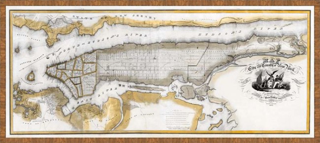
This map is big and beautiful. It shows the City and County of New York, with great details, including street names. Giclee sepia-tone print in a frame made of solid antiqued brown wood from Italy. This is a spectacular fine-art print, re-created on archival paper from an original map from the 1800s. Available framed only, in two sizes.
|
|
An Ingenious New Typeface Inspired by Old Maps, But Made With Algorithms
|
 |
|
Jonathan Hoefler-one of the best known typographers out there-has designed a new typeface: Obsidian. The 3-D, ornamental font harks back to the days of copper plate engraving, but it’s absolutely a product of computers and algorithms. Hoefler & Co.
|
Fonts may live in our computers, but every outline of every letter, number, and symbol in a
typeface is originally crafted by human hand. In the 1800s this happened via a copper plate engraving technique that allowed designers to create extravagant letters by hand, lending a uniqueness to maps and books of the time. These days, typographers use type design software, where letters show up as plotted coordinates that can be painstakingly tweaked in infinitesimal ways-nips and tucks that make, say, Baskerville distinct from Cambria.
“Typeface design doesn’t have rapid prototyping,” says designer Jonathan Hoefler, whose type foundry Hoefler & Co. is behind go-to fonts like Gotham, Gestalt and-yes-Hoefler. But to be sold globally, modern fonts can require more than 600 characters, to cover every language. That means designers hand-tuning individual vectors face a lot of demands. Now imagine creating those 600-and-more characters, but for an ornamental font, where vectors don’t only determine the curves of a “S,” but the three-dimensionality and lighting too.

Hoefler and senior designer Andy Clymer have figured out a new workaround: using custom algorithms to build typefaces. That’s how they designed Obsidian, the newest typeface from Hoefler & Co. Obsidian is a decorative, three-dimensional font created in a virtual environment that can simulate light falling upon any 3-D character in the set, thus eliminating the need to draw tens of thousands of shadows, one by one. The result is a convincing set of 3-D characters that harks back to the early days of type-making, but without all the flowery curlicues and animals that often accompanied 19th century letters.
These days, decorative typefaces aren’t that versatile. That’s a problem for the designers who might spend a year or more laboring over them. “We always worry in working on historical things that we’re going to wind up with a typeface that’s only usable for ragtime sheet music, or some kind of museum piece,” Hoefler says. “We really wanted Obsidian to be useful to contemporary editorial designs, to web designers, to be colorful and expressive but not heavily rooted in history.” To accomplish that, Hoefler and Clymer first started with one of their other designs, a type called Surveyor. That font already had some commercial success, so it became the spine for building Obsidian.
Once Clymer developed the algorithmic tools needed to quickly create a properly lighted typeface, Obsidian somewhat organically became a modern design. Because a computer decided on its highlights and lowlights, Obsidian doesn’t have hand-made gradients indicating a third dimension; it has carefully placed pixels. “This is sort of computationally driven, it really has that kind of texture and dimensionality,” Hoefler says. “For us it’s a whole new way of thinking about letters as a generative process.”
Hoefler and Clymer spent a year creating Obsidian. Hoefler describes the type foundry as being in the “raw materials” end of the business, meaning that it’s up to marketers and designers to get Obsidian out into the wild. He and Clymer will likely train their attentions on creating other unique fonts with similarly smart tools. That’s the next challenge: “How can we apply this set of tools we built without getting the same end result?”
|
|
IMIA Asia Pacific 2015 Board of Directors
|
|
President Bruce McGurty
UBD/Gregorys Explore Australia
Ground Floor, Building 1
658 Church Street, Richmond, VIC 3121 AU
Tel: +61 3 8520 6444 Fax: +61 3 8520 6422
Email: [email protected]
|
Director Will Pringle
Mapgraphx
Unit 2, 2-6 Yindela Street
Davidson, NSW 2085 AU
Tel: +61 2 9975 1388
Email: [email protected]
|
|
President Elect Mani Singh
NextByte Technologies Pvt Ltd
305 Aggarwal Millennium Tower-I
Netaji Subhash Place, Pitampura
New Delhi 110034 India
Tel: +91 98 10290075
Email: [email protected]
|
Student Liaison Danesh Prakash Chacko
403/200 LaTrobe Street
Melbourne Vic 3000 AU
Tel: +61 (0) 401827720
Email: [email protected]
|
|
Director Matthew McRobert
Land & Property Management Authority
346 Panorama Ave Bathurst NSW 2795 AU
Tel: + 61 2 6332 8133 Fax: +61 2 6332 8289
Mobile: +61 (0)409 120724
Email: [email protected]
|
Director at Large Sudarshan Karki
Dept of Natural Resources & Mines Qld
Landcentre, Podium 3
867 Main Street Woolloongabba, Qld 4102 AU
Tel: +61 7 389 63339
Email: [email protected]
|
|
Director Rob Boegheim
Hema Maps
PO Box 4365
Eight Mile Plains Qld 4113 AU
Tel: +61 7 3340 0099 Fax: +61 7 3340 0000
Mobile: +61 (0)418 774520
Email: [email protected]
|
Executive Director Noleen Zander
IMIA Asia Pacific Region
147 Unley Road Unley SA 5061 AU
Tel: +61 8 8357 1777 Fax: +61 8 8357 3001
Mobile: +61 (0)412 177570
Email: [email protected]
|
|
Director Igor Stjepanovic
GIS People
Level 54, 111 Eagle St Brisbane Qld 4000 AU
Mobile: +61 (0) 401 656 331
Email: [email protected]
|

|
|
|
Neoliberal Nightmare
Mark Maslin Argues that Geography Can Make a Difference
|
|
 |
| Professor Mark Maslin |
I was recently asked by an incredulous colleague why I was working in a Geography department. I answered that geography was the study of ‘the who, the where, and the how, of the past, present and future’.
I followed this up suggesting our subject has a profound role to play in both understanding and solving the great challenges of the 21st century. Of which I would suggest global inequality, global poverty, global security, environmental degradation and climate change are the most pressing. I hope this gave them a new appreciation of geography because in my opinion, by combining natural and social sciences, geographers are building a body of work that suggests the rules governing our society are not fit for purpose and new governance systems are required to deal with these immense challenges.
Let us investigate the state of our planet, starting with human health. Every year, seven million children die due to preventable disease and starvation. 700 million people go to bed every night feeling hungry and one billion people still do not have access to clean, safe drinking water. This is despite the fact that we have enough food and water for all seven billion people, but our political-economic system means that many people simply cannot afford them.
If we look at the Earth’s major biogeochemical cycles, all have been profoundly altered by humanity. For example, the invention of the Haber-Bosch process allowing the conversion of atmospheric nitrogen to ammonia for use as fertilizer has altered the global nitrogen cycle so radically that the nearest suggested geological comparison was ~2.5 billion years ago. Human actions have increased atmospheric CO2 by 40 per cent to a level not seen for at least 800,000 years, and may have even delayed the next ice age. This has increased the acidity of the ocean faster than any time in the last 50 million years.
Human action also impacts on non-human life. Global productivity appears relatively constant; however, the appropriation of a third of it for human use reduces that availability for millions of other species. Land use conversion for food, fuel, fiber and fodder, combined with targeted hunting and harvesting, has resulted in species extinctions 100 to 1,000 times higher than background rates, and likely constitutes the beginning of the sixth mass extinction in Earth’s history. We have also moved crops and domesticated animals and pathogens around the world, leading to a unique global homogenization of Earth’s biota.
Considering the huge influence humanity is having on the planet, it would be reasonable to assume that there should be some attempt to manage and distribute fairly the Earth’s resources. However this contradicts the dominant geopolitical and economic philosophy of the West, namely neoliberalism.
Neoliberalism encapsulates a set of beliefs which include: the need for markets to be free, State intervention being as small as possible, strong private property rights, low taxation, and individualism. Underlying neoliberalism is the seductive view that it provides market-based solutions to all our ills, and enables everyone to become more wealthy. This trickle down effect has been the central mantra of neoliberals for the last 35 years. Currently there are 3.5 billion people who live on less than $3.25 per day. In fact, according to Oxfam, the 85 richest people in the world currently own the same wealth as the 3.5 billion poorest people. If we want to eradicate extreme poverty and bring the very poorest people in the world up to $1.25 per day, at current rates of trickle down it would require global GDP to increase by 15 times, taking over 100 years. Under the current economic system, this would require a huge increase in consumption levels. So the neoliberal nightmare is that to lift people out of poverty, we need to make and consume more stuff. This all requires cheap energy, which will mainly come from fossil fuels, which accelerates climate change driving deforestation and environmental degradation, making those poorest of people more vulnerable.
So the geographic understanding of the world’s current and future social and environmental challenges suggests the very economic theories that have dominated global economics for the last 35 years are not fit for purpose. What is required is proactive and aggressive redistribution of wealth, both within and between countries. This could be via provisioning of free essential services, such as access to clean water, health care and education. Progressive taxation is essential to rebalance inequalities and this in turn reduces costs, as it has been shown that small social divisions within a country lower the health care costs and raise longevity. Outdated institutions need to be dismantled and governance structures fit for the 21st century created to accelerate sustainable development.
This is where ‘geography’ can make a difference by envisioning new political systems of governance, enabling collective action and with more equal distribution of wealth, resources and opportunities.
Mark Maslin is Professor of Physical Geography at University College London and a Fellow of the RGS-IBG
This story was published in the January 2015 edition of Geographical Magazine
|
|
IMIA Americas Strategic Planning Session & Board of Directors Meeting
February 06 – 08, 2015
Flamingo Las Vegas Hotel
Las Vegas, NV USA
|
IMIA Americas Members:
IMIA is in a competitive and challenging industry. We need to allocate our resources and develop strong internal member relationships and with strategic partners. IMIA is a business, which we are constantly trying to build.
The IMIA Americas Strategic Planning Session being held in Las Vegas, Nevada on February 6 – 8, 2015 is your opportunity to held define our goals. Some of the ideas we are working on are:
- Recognize where IMIA excels in the marketplace
- Provide regular outreach and personal service to members
- Go big with marketing
- Meet with our members to address individual and company challenges
What we must also remember what worked yesterday might not be right today. IMIA is focused on managing its growth. The key is to make sure our association does not become a dinosaur and… this is where as a member we need your input. These are complex issues and as we expand these issues become greater. We need to be “ready to pivot” when circumstances change.
Email to [email protected] your commitment to attend. Please email your name, company name, street address, city, state, zip, phone, fax, email address and website.
Schedule of Events
Friday, February 06
5:00 p.m.
Meet for Cocktails at Flamingo Las Vegas Hotel / Carlos ‘n Charlie’s / Off Hotel Lobby
nbsp;
6:30 p.m.
Dinner on Own / Group to Gather
Saturday, February 07
8:30 a.m./ Morning Coffee / Carson City II
9:00 a.m. / Strategic Planning Session / Carson City II
12:00 p.m.
Working Lunch / Carson City II
4:00 p.m.
Adjournment
5:00 p.m.
Meet for Cocktails / Carlos ‘n Charlie’s
7:00 p.m.
Dinner on Own / Group to Gather
Sunday, February 08
6:45 a.m. / Morning Coffee / Carson City II
7:00 a.m.
Board of Directors Meeting Carson City II
10:00 a.m.
Adjournment
Flamingo Las Vegas Hotel
| Shows in Las Vegas during the month of February…
|
If you prefer to phone in your reservation, please call the Reservation Center at 888.373.9855 to secure a reservation in the group block entitled International Map Industry Association. Please use the group code: SFIMI5
Note: The cut-off date for our group rate is January 30. After that date there is no guarantee of rate or room. The group rate is $89.00 plus the daily resort fee. The Group rate is available three days pre and post based on availability.
Resort Fee: A daily resort fee of $25.00 per room, per night plus the current Clark County room tax of 12% (tax is subject to change), will be charged in addition to the room rates set forth above. This fee includes:
Unlimited local phone calls (no long distance or international calls)
Two (2) guest admissions per day to the Fitness Center (does not include use of the spa)
In-room Internet access to include two devices per room per day (property wide and inter-property roaming available at that property for an additional fee).
|
|
|
EAME Announcement: IMIA Collective Stand at the Frankfurt Book Fair 2015
|
|
From 14 to 18 October 2015 the book industry meets in Frankfurt for the 67th time.There are plenty of good reasons to come in 2015 because…
|
|
|
|
|
IMIA Website Benefactors: Avenza Systems Inc., Esri, National Geographic Maps, NextByte Technologies Ltd., India, U.S. Geological Survey, and Williams & Heintz Map Corp.
|
|
|
|