
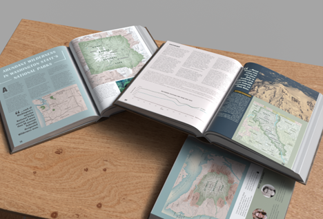
3D rendering of the final publication with all maps added to the layout.
In 2024, we introduced ArcGIS Maps for Adobe Creative Cloud, a powerful plug-in for Adobe Illustrator and Photoshop that extends ArcGIS technology to Adobe’s Creative Cloud applications. This integration enables you to incorporate mapping capabilities into your design workflows, making it easier than ever to create visually stunning, publication-ready maps.
Discover the ArcGIS-to-Adobe Illustrator workflow, showcased at the North American Cartographic Information Society (NACIS) conference, where Esri experts highlight the essential role of ArcGIS Maps for Adobe Creative Cloud. This workflow features the breathtaking national parks of Washington state: Mount Rainier, Olympic, and North Cascades, demonstrating the tool’s ability to bring geographic data to life in a visually compelling way.
This comprehensive guide walks you through each step, from setting up ArcGIS Pro layouts to exporting maps as AIX files and opening them in Adobe Illustrator with ArcGIS Maps for Adobe Creative Cloud. This streamlined process ensures that your maps maintain high quality and adhere to publication standards.
For a detailed look at creating high-quality maps for publications and to see the workflow in action, check out the full blog post by Sarah Bell. Don’t miss these valuable insights and tips that can elevate your mapping projects!