
The Nation in 3D: the U.S. Geological Survey (USGS) 3D Elevation Program (3DEP) Provides Quick Access to Digital Elevation Models (DEMs) and Trillions of Lidar Points.
USGS Lidar Explorer: https://apps.nationalmap.gov/lidar-explorer/
The mission of 3DEP is to respond to growing needs for high-quality topographic (elevation) data and 3D representations of the Nation’s natural and constructed features. The program acquires lidar data that supports many applications, including flood risk management, infrastructure and construction management, natural resources management, water supply and quality, forestry, emergency management, and other applications.
One of the challenges to working with 3DEP lidar data are the large file sizes and numerous tiles of data. USGS offers tools to make datasets easier to view and use for analysis.
Elevation Service:
The 3DEP bare earth DEM web coverage service lets users stream elevation data directly into desktop GIS software- no downloading needed. This webpage explains how to access and use the service, which provides access to 1-meter resolution DEMs (10-meter resolution where 1-meter data is not yet available) and is often the quickest way to work with 3DEP data.
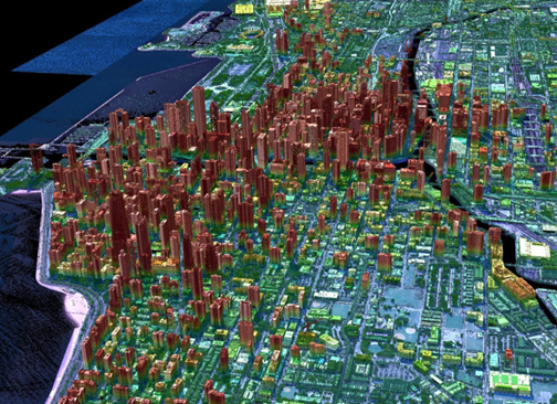
Lidar point cloud image of Chicago, IL.
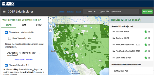
Lidar Explorer:
The USGS Lidar Explorer web application allows users to view 3DEP data availability, visualize lidar point clouds in 3D through a web browser, and download point clouds and/or DEMs for analysis. The National Map Downloader is another web application that provides access to lidar point clouds, DEMs, and many other USGS products such as 3D Hydrography Program datasets and US Topo maps.
Virtual Raster Tiles (VRTs):
USGS offers VRTs for seamless DEM datasets (1 arc-second, 2 arc-second, 1/3 arc-second resolutions). A VRT is a simple file that creates a mosaic dataset that makes it easy to extract only the tiles users need. This format can be used in R, QGIS, GDAL, and other languages to access 3DEP DEMs and use them in analysis.
VRT Download Links:
- 1 arc-second DEMs Cloud Access| Rocky Web Access
- 2 arc-second DEMs Cloud Access| Rocky Web Access
- 1/3 arc-second DEMs Cloud Access| Rocky Web Access
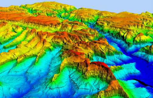
Bare Earth digital elevation model of Zion National Park, Utah, displayed as a shaded relief image.
Other Ways to Access Data Through the Cloud:
All 3DEP point clouds are available via a cloud requester-pays bucket. Refer to this USGS announcement about how to access data through the cloud. Organizations and companies outside of the USGS are also hosting 3DEP data on the cloud for public use. For example, 3DEP lidar point clouds in Entwine Point Tile (EPT) format are available in a public cloud bucket: the 3DEP data registry on AWS. 3DEP DEMs and point clouds are available through another cloud environment here: 3DEP Lidar Collection and 3DEP Seamless DEMs. Some platforms may include usage-based costs.
For questions or feedback about 3DEP, please visit the www.usgs/3DEP or contact [email protected]. Any use of trade, firm, or product names is for descriptive purposes only and does not imply endorsement by the U.S. Government.