The 2020 Forum Series’ final session, sponsored by NextByte Technologies, focused on technology-related issues in mapping. The panelists were: Dr. Este Geraghty, Chief Medical Officer, Esri; Dale Lutz, Co-Founder and Vice President of Software Development at Safe Software Inc.; and Dennis Nazarenko, Co-Founder and Vice President of Clear Sky Connect.
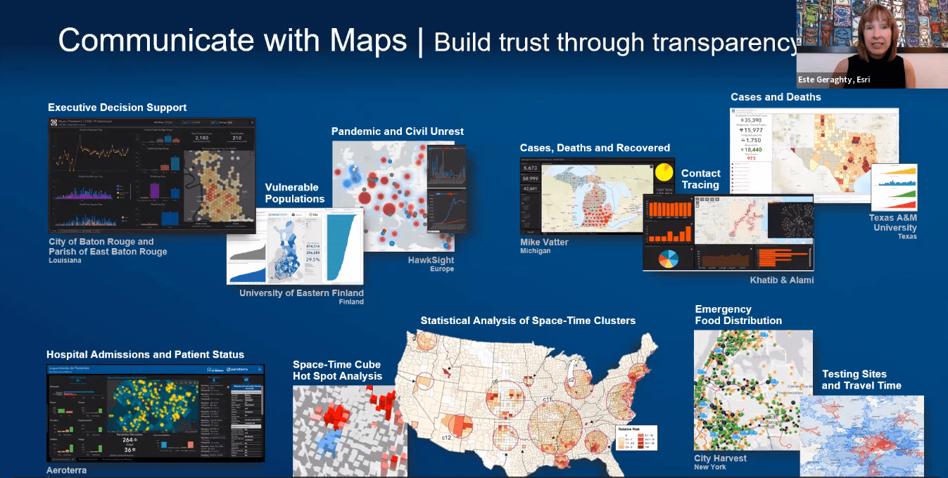
Geraghty spoke about how GIS has been used to support the world during the COVID-19 pandemic. “We saw tremendous use of data science to really understand disease spread and resource allocation, while also monitoring intervention pe rformance,” said Geraghty. “In times where there were not existing data resources, organizations used mobile collection tools to quickly start to gather important information. Esri helped groups to use GIS dashboards to be more successful in their efforts, which began with mapping the cases and the spatial and temporal spread of disease.”
The best-known example is the Johns Hopkins University COVID-19 dashboard, which since launching in January 2020 has been accessed as many as 2 trillion times, achieving, as Geraghty said, “a special place in history as the most viral GIS app the world has ever seen.” She continued by saying that the Hopkins dashboard is notable for having an emphasis on open data sharing from its inception, helping to influence hundreds of governments around the world to build their own dashboards. “Because the dashboard is updated multiple times per day —something that we’ve really never seen with health data — this builds a new public expectation for real-time information about everything COVID-related.”
Using data to map the spatial and temporal spread of the disease has also been effective, according to Geraghty. She pointed out the effectiveness of a visualization from the University of Virginia’s Biocomplexity Institute which uses different indicators to track cases of COVID-19 in various populations (such as the elderly or essential workers) or in various locations (such as nursing homes, dormitories or prisons). “We can overlay all of the various vulnerabilities and find the highest risk places for COVID-19,” said Geraghty. The use of cluster maps for humanitarian efforts (such as food distribution or accessibility to testing sites) in the app COVID Pulse “makes every county trend easily comparable to every other county trend across the country using spark lines,” Geraghty said. “There are some really complex and challenging issues in this effort that GIS can nicely support, including the management and monitoring of the vaccine administration and inventory system.”
 Lutz, Co-Founder and Vice President of Software Development at Safe Software Inc., looked at the growth of new technologies and highlighted significant trends in the industry.
“Location is more important than it has ever been,” Lutz said. When you think about the technologies that have evolved over the decades (GIS, cloud-based data, gaming, AR/VR), location underlies all of those.”
Lutz highlighted the integration of spatial and non-spatial data, which has exploded in recent years, integrating both files and live applications. “Cloud-first database vendors are adding spatial data support; traditional spatial database vendors are providing cloud offerings,” explained Lutz. Recent examples include Google BigQuery GIS and Amazon’s cloud databases. “The Gartner Report is forecasting that in 2023, two-thirds of all revenue related to databases is going to be databases in the cloud, a trend that cannot be ignored,” he said.
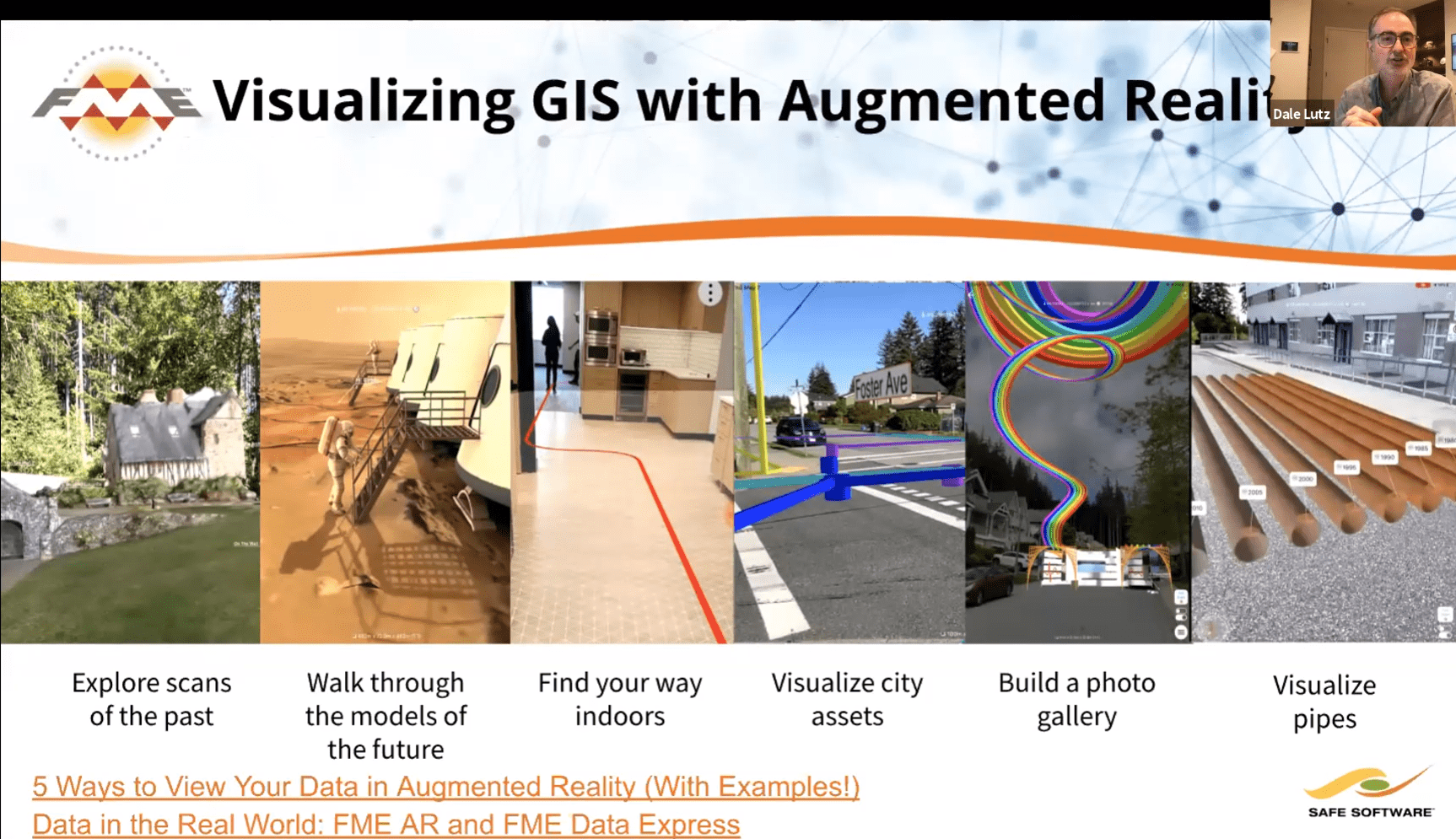
Luts also spoke about augmented reality (AR). “Geo AR (geospatially or spatially-aware augmented reality) can help you visualize GIS, including exploring scans of the past, walking thorough models of the future, visualizing city assets or building a photo gallery, for example. We really see this as an exploding frontier,” he said. “Geo AR presents the industry with a brand-new canvas to explore and apply to other kinds of maps in this new rich environment.”
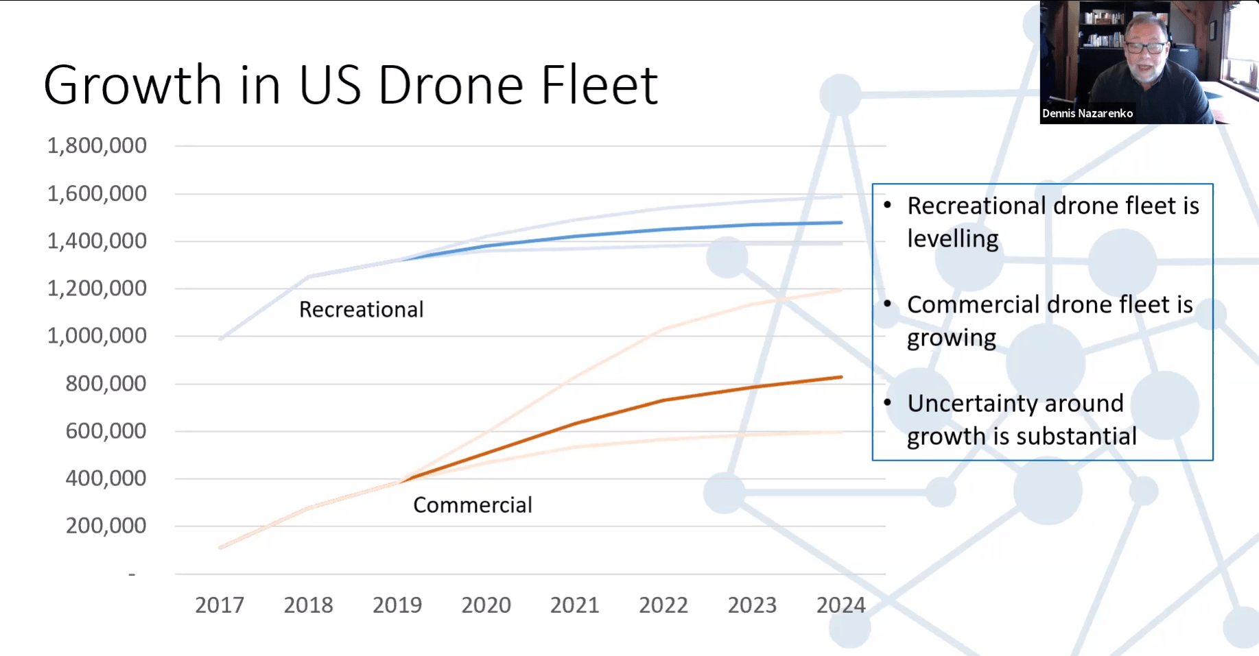
Dennis Nazarenko, Co-Founder and Vice President of Clear Sky Connect, was the final speaker of the session, shared details about the ever-expanding world of drones. “This may not be a new technology, but it is an area where there is considerable growth and opportunities for the mapping industry to consider,” he said.
From a mapping perspective, drones are a great way to collect, store and transmit data, including image and video data that may be new to the industry. How do you integrate that into operations when the geospatial aspects of these data are not always fully understood? Nazarenko pointed to findings in a 2019 report from Drone Industry Insight that said the use of drones for inspection and maintenance is particularly oriented to that sort of spatial data management and representation.
“I see future substantial growth in the data platform, the analytics and the information as service elements for the drone value chain,” said Nazarenko. “As the drone industry matures, we’re moving away from discussions focused on the drone hardware to complex examinations of higher-end value-added pieces around data analytics and data management.”