
IMIA at the Frankfurt Bookfair
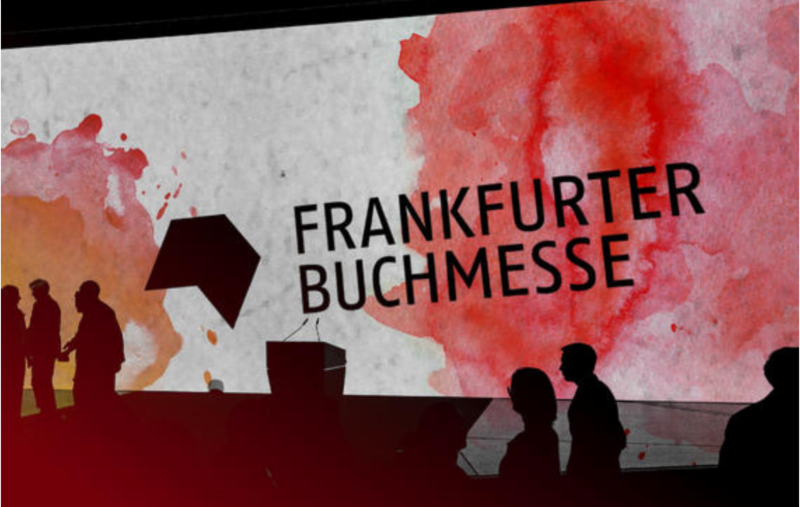
IMIA members will be exhibiting in our collective booth at the Frankfurt Bookfair , October 16-20, located in building 3.1, booth #J129. Companies include AGT Geocenter, Avenza Systems Inc., Benchmark Maps, HarperCollins Publishers Ltd., Interkart GmbH, MapSherpa, NextByte Technologies and XYZ Maps Ltd.
Join us as we continue to connect the business of maps worldwide, through impromptu discussions, scheduled meetings, and evening networking events. Learn more about the Bookfair.
The Future of Realtime Intelligence
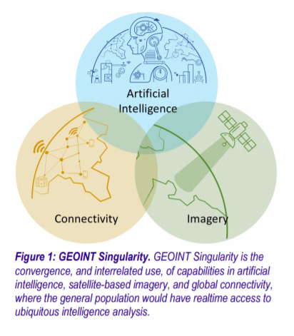 A study by Aerospace Corporation released early this month outlines a future in which “realtime Earth observations with analytics are available globally to the average citizen on the ground providing a tremendous wealth of information, insight, and intelligence.” Coined the GeoInt Singularity , it is hailed as a boon to location-based information intelligence that has the ability to support a myriad of consumer-facing applications – and a concern for military operators and warfighters.
The report’s focus is on the threats to military activity, notably the difficulty in maintaining secret operations on the ground, though it also briefly “acknowledges the privacy concerns of people around the world.” What are the broader implications and of such data being widely available – including night-vision and infra-red imagery?
The potential impact on vulnerable populations around the world could be huge, from the location and tracking of migrants and the homeless to the targeting of racial, religious and ethnic groups and geopolitical ‘adversaries’. The impact of large scale imagery could prove beneficial – or devastating if used for nefarious purposes.
While a GeoInt Singularity may never be reached, it is worth considering both the opportunities and implications of such data intelligence being made widely available.
New Member Profile – World of Maps
 IMIA welcomes new member World of Maps of Ottawa, Canada to our organization. Founded in 1994 as a true oasis for travelers, this independent map and bookstore carries a large assortment of topographic, international, street, and road maps of cities, states & provinces, countries & regions, continents, and the world.
Their thematic map offerings include nautical or marine charts, fishing maps, air charts, first nations, astronomy maps, geology maps, and more. Books include a focus on travel, adventure, exploration, history, nature, reference, fiction and non fiction. Canadian and international flags, patches, and lapel pins are also part of the product mix, as are large and small globe products. We are thankful to have World of Maps as a new member and look forward to fostering their success through our organizational network and events.
Printing Firms Upgrade to Bronze Annual Sponsor
 IMIA is sincerely grateful to Frederic Printing of Aurora, Colorado USA and William & Heinz Map Corporation of Capitol Heights, Maryland USA as our new Bronze Annual Sponsors. Both firms have been integral to the success of IMIA organization.
Established in 1878, Frederic Printing , an RRD Company, offers a range of services, including advanced mailing, fulfillment, digital printing, commercial and over-sized printing, and the latest in print technology platforms both locally and internationally.
 Williams & Heintz Map Corporation has been printing maps for entrepreneurs, government agencies, and map publishers for over 96 years, combining the highest quality pre-press, printing, and folding with industry leading knowledge and customer service.
Industry News
CyberWire host Dave Bittner talks to Ben Yellin from the University of MD Center for Health and Homeland Security on the privacy implications of geofencing. They discuss the use of micro-targeting in political campaigns, the privacy implications of sharing personal geolocation data and the potential for regulation of the sales of such data.

TomTom Maps Out Revamp With Bet on Self-Driving Cars
(Bloomberg) — Once a household name for its satellite navigation for cars, TomTom NV has taken a backseat in recent years as smartphones, loaded with apps like Google maps, surged in popularity.Now the Dutch digital mapping company is betting…

NASA’s Multiple Views of Hurricane Dorian from Space
Several instruments and spacecraft from NASA’s Jet Propulsion Laboratory in Pasadena, California, have eyes on Hurricane Dorian, capturing different types of data from the storm. An infrared image of Hurricane Dorian, as seen by the AIRS…

Animated Maps: A Century of UFO Sightings
A look back at over a century of reported UFO sightings. This animated map was made using Esri’s ArcGIS Pro, Cinema 4D, X-Particles,

Upcoming Industry Events
|
Frankfurt Bookfair
Oct. 16 – Oct. 20
Frankfurt, Germany
|
Learn More |
|---|---|
|
NACIS 39th Annual Meeting
Oct. 16 – Oct. 20
Tacoma, Washington, USA
|
Learn More |
|
London Bookfair
March 10 – March 20
London, UK
|
Learn more |
|
AutoCarto 2020
May 20 – May 22
Redlands, California, USA
|
Learn more |
")
Platinum Sponsors

Gold Sponsors
![]()
![]()
![]()
Silver Sponsors
Bronze Sponsors
