Travel Back in Time with Cold War Maps from East View
During the Cold War and before easy access to high-resolution satellite imagery, the USSR Ministry of Defense was secretly mapping the entire world in astonishing detail, including major cities as well as medium-sized and inland towns. These Soviet Military City Plans are aesthetically striking, exceptionally detailed, and a testament to the sophisticated and far-reaching cartographic operations of the Soviets.
For over 30 years, East View has been collecting declassified Soviet materials and now has the largest collection of Soviet Military City Plans in the world. Today, East View offers Soviet Military maps for hundreds of global cities through various channels including East View Map Link, East View Geospatial, Longitude Maps, and, coming soon, Amazon. East View even has reprints of the Soviet Military City Plans available in select physical stores, such as the gift shop at the Museum of Russian Art (TMORA) in Minneapolis. TMORA Collection Associate Chris Seberson shares that “the Soviet map reproductions by East View are just another great way we can provide a whimsical yet informative item that further engages our guests at TMORA Shop.”
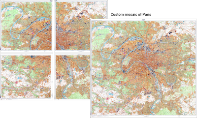
These collectible, high-resolution reprints are produced by East View Map Link and delivered on premium, acid-free, matte paper. East View Map Link offers other finishing services including lamination and framing for wall art. Custom map options are also available and are a nice solution for cities covered by more than one map sheet, such as the custom mosaic of Paris pictured here.
Own a piece of history with high-quality reprints of Soviet Military City Plans from East View.


