
USGS Topographic Mapping: History and Innovations
The U.S. Geological Survey (USGS) was entrusted with mapping the Nation in 1879 and has been the primary civilian mapping agency of the United States ever since. USGS topographic maps fall into three product categories: historical topographic maps, the current USGS topographic map series US Topo, and the next generation of topographic maps, OnDemand Topos. Together, these products illustrate the 140+ year legacy and evolution of topographic mapping at the USGS.
Historical Topographic Map Collection
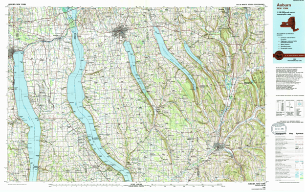
Historical 1:100,000-scale USGS topographic map of Auburn, New York published in 1986
The Historical Topographic Map Collection (HTMC) is the set of scanned images of USGS topographic quadrangle maps originally published as paper documents. Maps were produced as early as the 1880s and range in scale and extent from 1:24,000 to 1:250,000-scale. As of today, there are approximately 185,000 scans available through digital repositories available to the public at no cost. USGS continues to scan and release additional historic USGS topographic maps as additional items are identified as missing from the collection.
From the 1880s through the advent of computer technology, topographic maps served as the essential instrument for the integration and analysis of place-based information. USGS mapping techniques evolved over 140+ years from field surveys to photogrammetry to early GIS analysis. This forms the basis of the technology behind the USGS Historic Topographic Map Collection.
US Topo
US Topo is the current USGS topographic map series for the Nation. These are modeled on the legacy 7.5-minute maps but are mass-produced from GIS databases of The National Map and published as digital documents. The launch of the US Topo program in 2009 marked a transition to a modern digital production that leveraged process automation through server infrastructure production to a distributed cloud environment.
Most US Topos have been updated every three years (with exceptions in Hawaii, Alaska, Puerto Rico, and the U.S. Virgin Islands) to provide nationally consistent coverage. Every US Topo map includes imagery, shaded relief, metadata, transportation, and hydrography, as well as other data layers from the National Map. US Topo products are 1:24,000-scale topographic maps produced for the United States (1:25,000 scale in Alaska, 1:20,000 scale in Puerto Rico & U.S. Virgin Islands). US Topo maps are created through a semi-automated workflow, with most of the manual components being tied to annotation review and quality checks.
GIS-based cartography and remotely collected source material enabled automated processes and decreased map production time from hundreds of hours to about a day. USGS has and continues to evaluate opportunities to improve and automate production processes to deliver timely, high-quality, standard, national coverage of topographic information to users.
The foundation of the US Topo modernization set the stage for USGS’s newest product offering which is building on top of a server infrastructure to distribute cloud production with big data. These technology advancements enable USGS to rapidly disseminate data and products to end users in a fully automated environment.
Free and immediate downloads of historical topos or US Topo are available through topoView or The National Map Downloader.
topoBuilder and OnDemand Topos
In early 2022, the USGS launched a new topographic map production system, called topoBuilder. The system is 100% automated, allowing users to request topographic maps with the best available National Map data and receive the map by email, usually within a few hours.
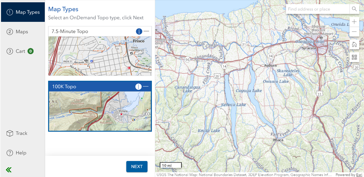
topoBuilder web application
From topoBuilder, users can request a map when they want, where they want, and with the data content they want. The product is called an OnDemand Topo and is available on a free and unlimited basis. The topoBuilder application allows for a variety of customizations such as choice of format, area of interest, and National Map content. OnDemand Topos are truly created ‘on-demand’, this includes shaded relief and contours generated from the best available elevation data, the latest national trails, and the latest GNIS names at the time of request.
The first OnDemand Topo type, the 7.5-Minute Topo, is available at the same scales as the US Topo products. As a direct result of the automated on-demand nature of the system, USGS was able to expand coverage beyond US Topo to include the Pacific U.S. Territories (American Samoa, Guam, and Northern Mariana Islands).
The recently released 100K Topo is the first of several planned additions to the OnDemand Topo product catalog. This is the first time in over 30 years that USGS has produced maps at the 1:100,000-scale. The 100K Topo is considered a medium-scale map, ideal for providing a broad topographic overview of landscapes. The 100K Topo is inspired by the 30- by 60-minute map series published by the USGS through the end of the 20th century. While 100K Topos contain less detail than the 7.5-Minute Topos, they still provide enough information for many traditional and recreational uses as well as science and planning.
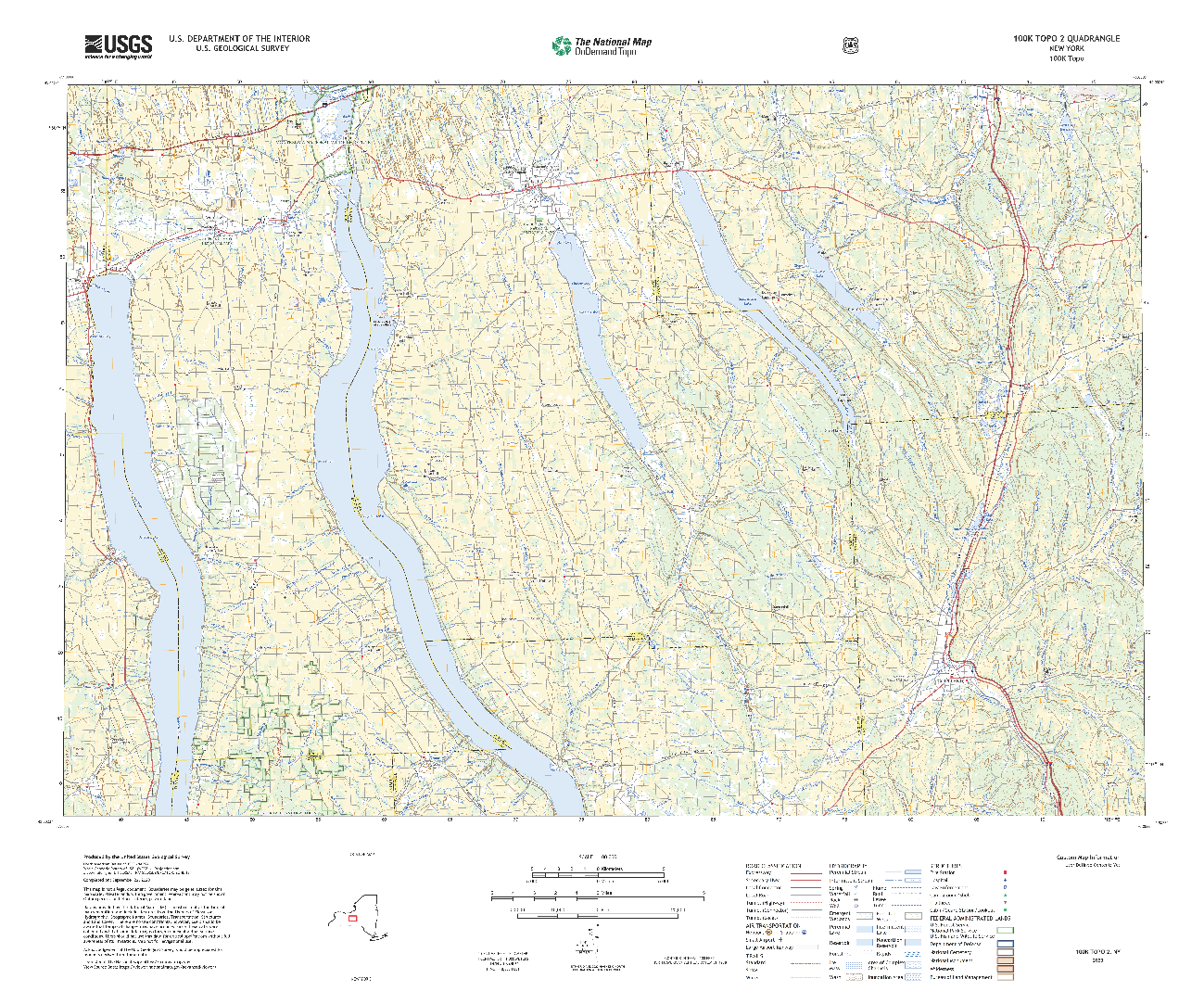
100K OnDemand Topo of Auburn, NY
Topographic Information for the Future
What USGS is doing with topoBuilder is more than just getting maps into users’ hands and it isn’t just about mapping the nation anymore; it’s about leveraging the rich history of topographic mapping at the USGS, with the latest advancements in technology. To accomplish this, USGS is changing how we work; we are shifting our focus from production to innovations. With systems like topoBuilder, USGS is looking at how we can build great software by utilizing cutting-edge technologies to get users the best information and maps that we can. topoBuilder is still in its infancy so how USGS continues to develop this system and meet those innovative initiatives is something that USGS continues to develop and learn.
Artificial Intelligence (AI) applications within Geography and Cartography, or Geo.AI, is the next stage of innovative technology. Geo.AI capabilities will be able to use deep learning to simultaneously operate multiple machines in the cloud, each with a large amount of data stored and memory to serve geographical information. This has major applications to improve and improve modeling, planning, resource allocations, and decision-making. USGS has a team of researchers that are looking at machine or deep learning and the USGS is excited to see what the application of Geo.AI can and will mean for the USGS and our mapping program.
For any questions, help, or feedback on USGS topographic maps, please contact [email protected].